Wayne County Scenic Ride
The Settlers Inn founder Jeanne Genzlinger shares one of her favorite local biking routes, which can be tailored to suit your skill level and your schedule. Jeanne suggests you drive from our Poconos inn to the suggested parking area to begin this ride.
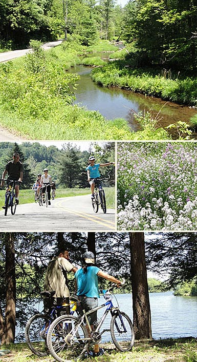
Bikers looking for a quick 15-mile loop along a rural road that parallels a babbling brook will enjoy this woodland tour. And, experienced cyclists up for some steep hills will find the burn worth it as you traverse approximately 33.5 miles of rolling hills and farmland that typifies northern Wayne County in the Pocono Mountains.
Whichever option you choose, there’s plenty of opportunity to spot a great blue heron or encounter deer, squirrels and rabbits as the pristine Dyberry Creek, often rimmed by lush forests, is always near-by.
Directions:
- From The Inn’s entrance, make a left onto Route 6 West, followed by an immediate left at the traffic light. Continue along Route 6 to Honesdale, making a right onto Church Street, which funnels drivers through town toward Route 191 N. Approximately 4 miles past Honesdale on Route 191 make a left at the yellow diamond shaped sign indicating a T. Cross the bridge and make an immediate right onto Dug Road. You will soon see a small parking area on your left where you can leave your cart.
- Bicycle up the incline on Dug Road, and at the 2-mile point bear right where Upper Woods Road meets Dug Road. The rolling Dyberry Creek parallels on your right. This is a beautiful ride with rolling meadows, babbling brooks, woodlands and wild flowers. There is very little car traffic on Dug road and the setting is bucolic.
- About 4.2 miles into the ride, bear right at the Y onto Shieldsboro Road. You’ll immediately see a small barn on your left as you make the gentle incline, and soon you’ll pass the PA State Game Commission public sporting range.
- About 7.5 miles into the ride, you’ll encounter a stop sign where Dug Road intersects Route 371. Cyclists looking for a 15-mile outing may want to loop back to the parking area. The ride back is a joyous slight downhill.
- About 7.5 miles into the ride, you’ll encounter a stop sign where Dug Road intersects Route 371. Cyclists looking for a 15-mile outing may want to loop back to the parking area. The ride back is a joyous slight downhill.
- Or, for a more challenging ride, continue for 9.3 more miles to the Village of Equinunk by making a right onto 371 East, also called Great Bend Turnpike. Cross the bridge and make an immediate left toward Pine Mill. Climb a steep 2.8 mile-incline then enjoy a leisurely coast along this rural road. Jeanne suggests a break at the Lower Woods pond. About two miles from the intersection of rte 371 turn left on Lower Woods road and in a short distance turn right to view the lake, or even opt for a swim.
- At about 7.2 miles from the top of the incline, bear to the right as a road intersects on your left. The Dyberry Creek will now be on your left and you’ll pass the Pleasant Valley Camp Site.
- You’ll soon enter the village of Equinunk, following a curve in the road past some homes then climbing a small hill.
- At the town’s main intersection, The Equinunk Historical Society will be on your right and Hunt’s General Store directly in front of you. Enjoy a bite to eat and take in the country charm at the store, then loop back to the parking area on Dug Road to complete this 33.6-mile loop. This is a true Wayne County rural scenic ride.